Pah Wah Point: Difference between revisions
No edit summary |
m Reverted edits by Ccac-garbage (talk) to last revision by Ccac |
||
| Line 1: | Line 1: | ||
{{Trail | {{Trail | ||
|imagelink= | |imagelink= | ||
Latest revision as of 21:20, 22 September 2011
| Vital Statistics | |
|---|---|
| Town | Orleans |
| Where | Off Namequoit Road, East Orleans |
| Distance | 0.35 mile |
| Surface | Pine needle with some roots |
| Last Visited | 2006 |
| Ratings | |
| Overall | Easy |
| Walking | Excellent |
| Running | Fair |
| Biking | Poor |
| Hiking | Fair |
About The Trail
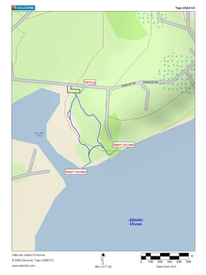
Too short to make much of a run but a nice Sunday walk with an overlook of Paw Wah Pond and a small salt marsh. Beach access to Little Pleasant Bay at two junctions of the trail allow you to walk along the beach out around Namequoit Point but keep in mind that most of this is private land. Nice views of Pochet (North Beach), Sampson Island and Barley Neck. A very easy trail to walk, there is nothing challenging and a scattering of benches and picnic tables make this a nice spot for a weekend brunch. The trail makes a nice 3/10 mile addition to an exploration of Namequoit and Viking Roads but is too short to make much of a workout by itself. An additional trail maintained by the Orleans Conservation Commission is accessible off Namequoit Road on the right approximately 1/4 mile from the intersection with Route 28 but the trails do not connect.
Getting There
Take Route 28 to Namequoit Road and follow Namequoit for about a mile until you reach the private section of the road. Proceed past the private road sign about 100 feet and parking for 8 to 10 cars is available on your right. Please respect the local residents’ private property and park and hike in designated areas only.
Maps
