Coy's Brook Woodlands
| Vital Statistics | |
|---|---|
| Town | Harwich |
| Where | Lothrop Avenue |
| Distance | Approximately 1.2 miles on three trails |
| Surface | Leaf and pine needle covered sand paths |
| Ratings | |
| Overall | Easy |
| Walking | Excellent |
| Running | Good |
| Biking | Fair |
| Hiking | Good |
About The Trail
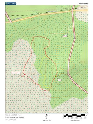
In memory of Harold and Beatrice Dickey and maintained by the Harwich Conservation Trust, this short trail system winds through 30 acres of upland pine forest above the Herring River marsh. Most of the trails are packed sand covered with leaf and pine needle debris and are well marked with red, yellow, white, and red-yellow blazes. Two benches provide spots to meditate or look out over the marsh. A small spur off the red trail will take you to the marsh’s edge and a kayak or canoe launching spot if you’re willing to carry your boat the 1/4 mile along the trail. Part of the Harwich watershed, the white trail will take you out to Lothrop Avenue and around the large water tower. The white trail entrance sports a small wooded bike rack. Also look an old dammed, man-made brook just off the white trail with a small pedestrian footbridge which feeds into the Herring River. The western spur of the red trail runs alongside an old cranberry bog which is slowly being reclaimed by the woodland. Coy’s Brook runs along the south of the woodland area and feeds into the Herring River.
Getting There
From route 6, take exit 10 and head south on Route 124. At Harwich Center, turn right and continue straight on to Great Western Road. After a mile and a quarter, turn left on Lothrop Avenue. The parking area will be about 3/10 mile on your right.
Maps
